


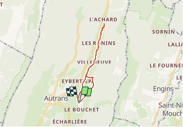
AUTRANS - LE BOUCHET

maupassant38
User

Length
10.7 km

Max alt
1214 m

Uphill gradient
252 m
Km-Effort
14 km

Min alt
1071 m

Downhill gradient
252 m
Boucle
Yes
Creation date :
2020-09-13 08:54:23.495
Updated on :
2020-09-13 14:06:04.686
2h16
Difficulty : Easy

FREE GPS app for hiking
 SityTrail
IGN / Geographical institutes
SityTrail Plus
The world is yours!
About
Trail Walking of 10.7 km to be discovered at Auvergne-Rhône-Alpes, Isère, Autrans-Méaudre en Vercors. This trail is proposed by maupassant38.
Positioning
Country:
France
Region :
Auvergne-Rhône-Alpes
Department/Province :
Isère
Municipality :
Autrans-Méaudre en Vercors
Location:
Autrans
Start:(Dec)
Start:(UTM)
701138 ; 5005460 (31T) N.
Comments